Canal Maps
Village Needlecraft is no longer trading as a business,
howevor some of the kits are still available from stock
Please contact Les Perry via email or Phone to check if
a kit is still in stock prior to making an order
Email
anne@annegale.plus.com
Tel 01539 566919
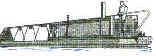
The Canal System of the UK developed from the 1760 became the highways
of their day and revolutionised the transport of goods inland. Towns and
industry built up around the development of the system which is now our
heritage.
The canal system itself is now used almost totally for leisure purposes, a
peaceful and tranquil way of visiting the historic heart of England.
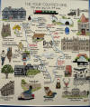
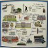
In our series of maps we have illustrated places of historic and general
interest within the area covered.
We hope you enjoy your visit in Counted Cross Stitch to our history.
Click on picture for larger view
-1_small.jpg) Leeds
& Liverpool Leeds
& Liverpool
 4
Counties Ring
4
Counties Ring
-1_small.jpg) Leicester (GU) Leicester (GU)
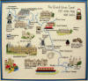 Grand
Union Grand
Union
-1_small.jpg) Llangollen Llangollen
-1_small.jpg) Oxford Oxford
 Cheshire Ring
 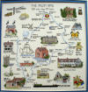 Avon
Ring Avon
Ring
-1_small.jpg) Staff & Worc.
Staff & Worc.
-1_small.jpg) Kennet
& Avon Kennet
& Avon -1_small.jpg) Waterway Heritage
Waterway Heritage  Shropshire
Canal Shropshire
Canal
 River Thames NEW
 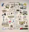 Lancaster
Canal NEW Lancaster
Canal NEW
Click on picture for larger view
|